I've been wanting to get into Ground Penetrating Radar for some time now, but they are expensive beasts. Rather than buy a loft conversion for my lovely and long suffering wife, Merryn, I have been saving up for one of these, and now have enough to make a purchase. Aren't I mean.
With so many choices, which one to buy? It doesn't help that there is little comparative information out there, making it difficult to choose between them. The mostly commonly used GPR cart systems in archaeology (as far as I can tell) are the
GSSI SIR-3000, the
Mala X3M and the
S&S Noggin. Fortunately, a friend of mine (Hi Dave) had used all of these and had some words of wisdom to impart. Apparently there were two areas where these systems varied significantly. Firstly, there are variations in the way that data is stored. Whilst the Noggin will store raw data, the other two systems will record with the gain applied when surveying, which causes problems with processing the data later on. Secondly, there are variations with the way that the systems handle GPS data, with the GSSI having problems with it, the Mala performing somewhat better and the S&S Noggin dealing with GPS in the best way. So the Noggin is the clear winner right? Well apparently it is also the most expensive, and there is no local support here in the UK, so if something goes wrong, you have to send it overseas.
It was then that I met Erica Utsi at the
NSGG conference at the end of last year.
Utsi Electronics produce a cart system based on the
Groundvue 3, which apparently stores data raw like the Noggin does, but doesn't cost a fortune and is produced here in the UK! I decided to try hire one for a day to see how I got on with it, hence this monster of a blog post. I must stress at this point that I only know enough about GPRs to be dangerous, so everything I say should be taken with a pinch of salt. I had two test sites on which I wanted to try out the machine, sites which I already knew a lot about, so I knew what I was expecting to find. Here is how I got on.
The first site is part of the
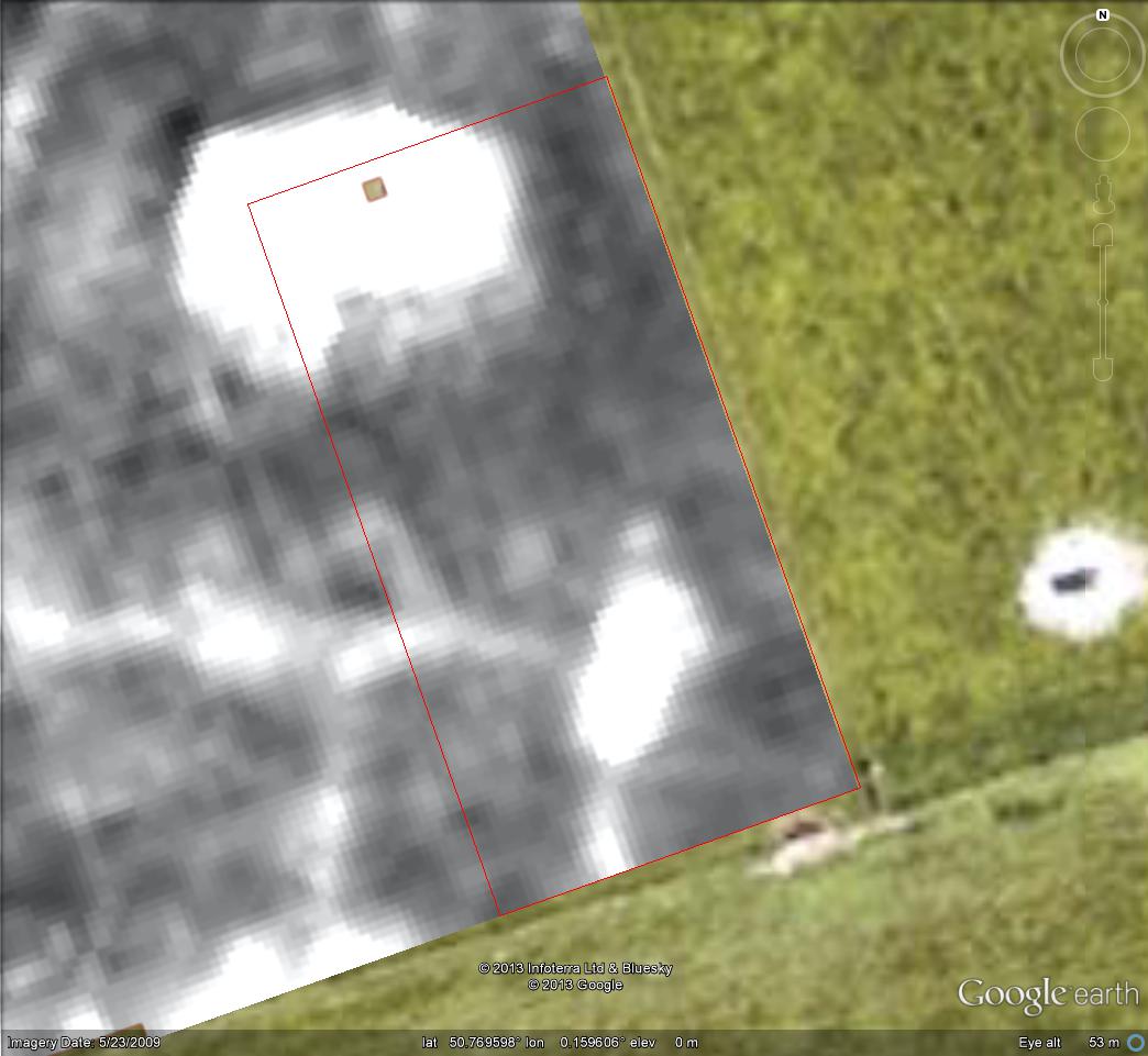
Culver Project, one of my favourite sites in Sussex. The site is on clay, which is one of the geologies that radar has trouble with, especially when it is wet. Whilst the ground at the time of the survey wasn't sodden, it was far from dry, so this was a real stress test for the machine. The other thing that I wanted to test, which this site allowed, was how the radar performed with different surfaces, in this case tarmac, grass (shaggy but not long) and a ploughed field (flat). As you can see from the image below, there is a Roman road crossing the site, which is know to consist of a single layer of flint. The side ditches can be seen on the magnetometer survey to the north, and the road surface can be seen in the earth resistance survey to the south. The road is known to be in good condition to the south, but there was a crop in the field, so only a single traverse was done at the edge of the field. A further survey area, 40 metres wide, covered the road and the grass verge to the south of it.
The Roman road we are investigating
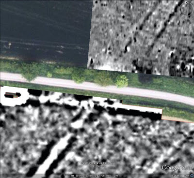
Despite the harsh conditions for the GPR, the road was certainly visible in the results, as you can see below. This is the best vertical traverse of the group, and you can see the road surface in the middle at the bottom of the image.
40 metre traverse along the tarmac road and across the Roman road
Creating a horizontal time slice shows the road surface heading diagonally across the image, but not the side ditches.
Time slice showing the road surface
Whilst the road was certainly visible in the results, there were issues. The road did not show very well under the grass verge, with a lot of messy readings in the results. The single traverse in the field to the south did not show the road at all. On the grass, ground coupling may have been an issue because of the shaggy grass, but that wasn't a problem in the field to the south. It may be that the road has protected the area below from the worst of the damp weather, leaving the signal in the grassed and field areas subject to higher levels of attenuation from the water content. It may be that GPR in clay fields such as this is best left to just after harvest time, leaving a rather small window of opportunity for survey.
Whilst we were at Culver Farm, I took the opportunity to test out the encoder wheel on the cart, to see how accurately it performed. One of the things I am hoping to do with the GPR is to do isolated long traverses across fields to locate Roman roads crossing through, without having to spend time doing a full survey. We laid out a 100 metre tape and recorded a traverse. On download, the traverse was found to be 102 metres, which is not disastrous, but not ideal. It may just need recalibrating, but traverses can be stretched to the right length, so no great issue.
The second site is on chalk, a geology that GPR is more at home with, looking for walls, which GPR is good at looking for, so this site is nowhere near as harsh as the last one. The site is a deserted village on the downs at
Exceat. There was a church here, but other than the lumps and bumps on the surface, the only sign that anything was here is a large stone in the middle of where the church stood, which was erected after excavations in the early 20th century. Greg Chuter had organised an earth resistance survey, to try to find out what was around the church, and the results clearly showed the church and the churchyard wall. Part of the site, outlined in red in the image below, was then surveyed with the GPR.
Survey area shown over the earth resistance survey
As you can see from the three time slices below, the GPR performed very well here, highlighting features much clearer than the res survey, with some interesting phasing information as well. The expected graves in the churchyard did not show up, but it may be that I did not record deep enough. I don't think I hit the chalk geology with the depth I had the radar set to. I am very happy with the results from this site.
Time slice at 9ns
Time slice at 15ns
Time slice at 18ns
Finally, here is a
youtube video of the slices, from top to bottom, and a picture of the intrepid John Kane using the machine. Thanks John.
Intrepid John Kane with Groundvue 3 cart
So those are the test sites. What about the machine itself? There weren't any real problems in the field. The data logger is simple to use and does the job, though being based on MS-DOS, it isn't particularly pretty. Downloading the data to a computer was a bit of a pain though. Downloading is via a network cable, which means unplugging yourself from whatever network you are plugged into to plug in the datalogger. You then need to change some setting on your computer to make the connection work. Unfortunately for me, I run Windows XP in user mode, for security reasons, and I wasn't able to change those settings, so I had to log in as admin, change the permissions on my account before changing the network settings. After that, the download is simply a matter of cutting and pasting the files as if from a network drive. Adding another network card to my computer would save the hassle of changing all that each time, but it would have been better to have the data on a removable memory card, or have a USB connection to the data logger that would act as a USB mass storage device.
There are two software options for processing the data from a Groundvue,
ReflexW and
GPR Slice. The latter is nice, but hideously expensive, so I borrowed a copy (version 6) of the former, which is somewhat cheaper, to try it out. ReflexW is certainly fully featured. There are an extraordinary number of things you can do with it, most of which you will never need to use. There wasn't anything that I found missing. The user interface is somewhat clunky though, as a lot of scientific software can be. It also didn't help that English is not the first language of the person who wrote it, so the manual can be a bit difficult to follow at times.
So in summary, though I haven't tried out other systems to compare, I was certainly happy with how the day went, and I will be buying a Groundvue 3 for myself.